

Our proud past
Over 300 years of shared history, dedication and experience have brought us to where we are today. Explore our archives to see some of the records we’ve collected along the way.
1708
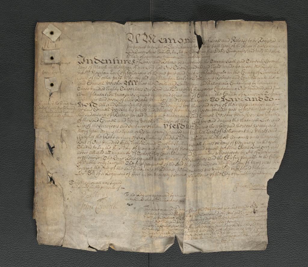
The Registry of Deeds was established in 1707 by an Irish Act of Parliament entitled ‘An Act for the Publick Registering of all Deeds, Conveyances and Wills that shall be made of any Honors, Manors, Lands, Tenements or Hereditaments’. The very first Memorial was registered on 29 March 1708, capturing a deed of Indenture and Release between the Right Honble Nanfan Earl of Bellomont of the one part, and Connell Vereker of Ballinscala in the County of Limerick Gentl of the other part.
1782

An Act of the Parliament of Ireland to promote trade and manufacture by regulating and encouraging partnership came into effect in June 1782, with an amending Act in 1786. The Acts required the registration of business partnership with the Registry of Deeds. The dissolution of the partnership if that arose was also recorded in the Registry of Deeds.
1805
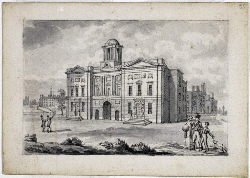
The Registry of Deeds was initially based in a private house and then moved to the Lower Castle Yard of Dublin Castle. In 1805, it moved to Inns Quay, Dublin and occupied three stone-vaulted rooms and a closet on the ground floor. Whilst its location was considered convenient due to its location to the Courts, conditions were very cramped and unsuited to hold records. In 1831 the Office moved to its current location on Henrietta Street, which was purpose built to hold public records.
1824
The Select Committee for the Survey and Valuation of Ireland, also known as the Spring Rice Committee, was established in April 1824 to examine the requirement for a uniform valuation system for tax purposes in Ireland. The committee laid its report before parliament on 21 June 1824, which outlined that having accurate maps was essential to the valuation work. The Ordnance Survey Office in Ireland was formed to carry out the survey of the entire island of Ireland. The Office was initially part of the British army under the Ministry of Defence and was based in Mountjoy House in Phoenix Park, Dublin
1827

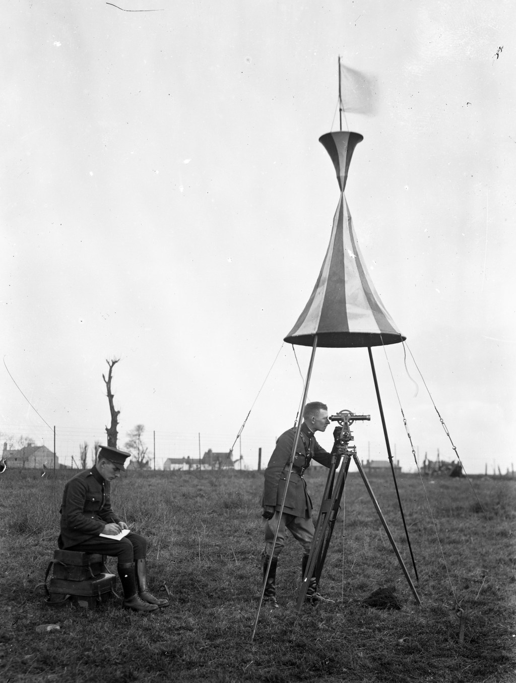
A crucial part of this mapping of Ireland was the careful and accurate measurement of the Lough Foyle baseline, stretching for 8 miles. The work was completed over 60 days between September 1827 and November 1828. An original apparatus, ‘Colby’s bar’ was used to measure the baseline. The Lough Foyle Baseline was remeasured in 1960 using a Tellurometer and the result differed from the 1828 value by only 2.5cm, a convincing demonstration of the precision of the original survey.
1830
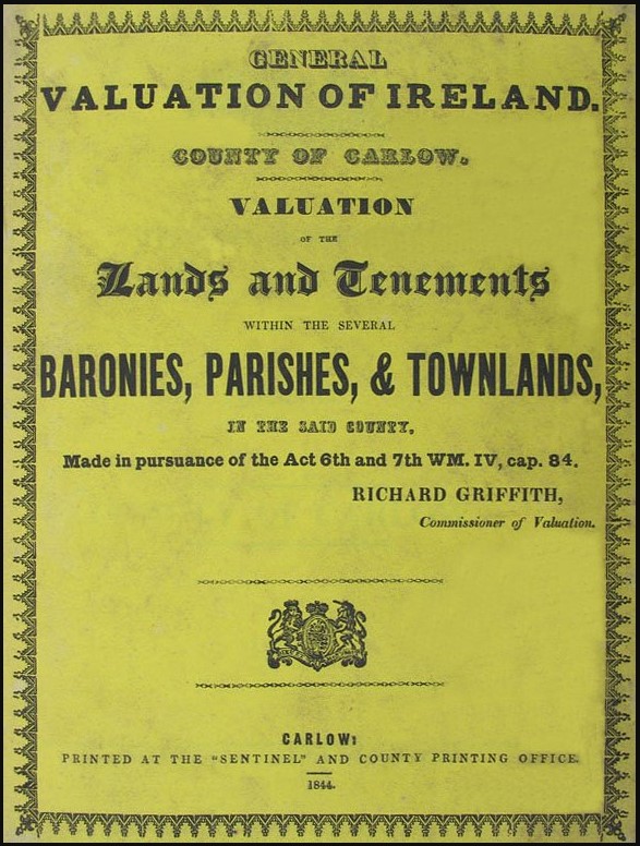
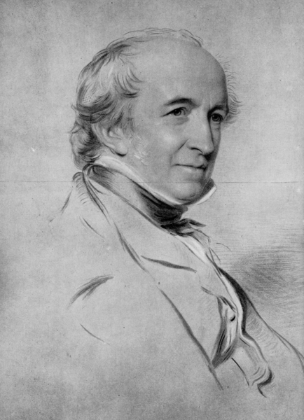
The first Valuation Act was passed in 1826, and fieldwork began in 1830 in County Londonderry, overseen by Richard Griffith, and progressing from north to south as Ordnance Survey maps were published. The townland valuation, conducted under Acts from 1826 to 1836, aimed to value properties in counties, baronies, parishes and townlands. The tenement valuation started in 1844, driven by the introduction of the poor law and critical reviews of the townland valuation. This method recorded every individual tenement and occupier’s name.
1832
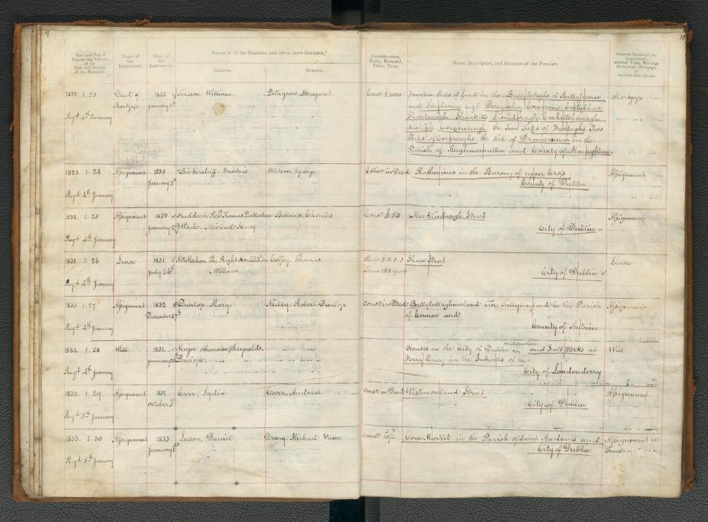
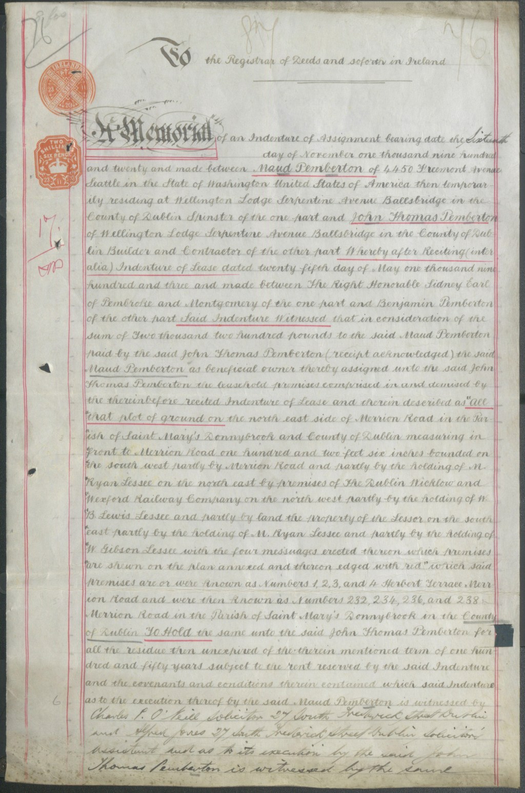
The Registry of Deeds Act (Ireland) of 1832 was a very significant piece of legislation in the history of the Registry of Deeds. It introduced a new numbering system for registered deeds, more detailed indexing of names and lands, and the creation of ‘abstract books’ which sets out the summary information regarding a deed registered.
1846

The original survey of Ireland, at a scale of 6 inches to 1 mile, was completed in 1846 under the direction of Major General Thomas Colby. Ireland became the first country in the world to be entirely mapped at such a detailed scale. The survey also gathered information on local customs, place names and archaeology, documenting the pre-famine landscape of Ireland.
1864

By the mid-1860s, the entire country was valued in tenements and the initial valuation of Ireland was complete. The preliminary valuation prepared for appeals was published as the Primary Valuation of Ireland between 1847-1864. It was also known as Griffith’s Valuation, after Richard Griffith who was Commissioner for Valuation between 1830 and 1868.
1887

In 1887, the Ordnance Survey began to re-survey populated areas of Ireland at scale of 25 inch to 1 mile. The various Land Purchase Acts introduced in Ireland in the late 19th century permitted tenants to take out mortgages and purchase the land they worked on landed estates. However, the original 6 inch survey which focused on the boundaries of townlands, wasn’t considered detailed or accurate enough to calculate the areas of individual plots. Mountainous and certain bog land areas were not resurveyed.
1891
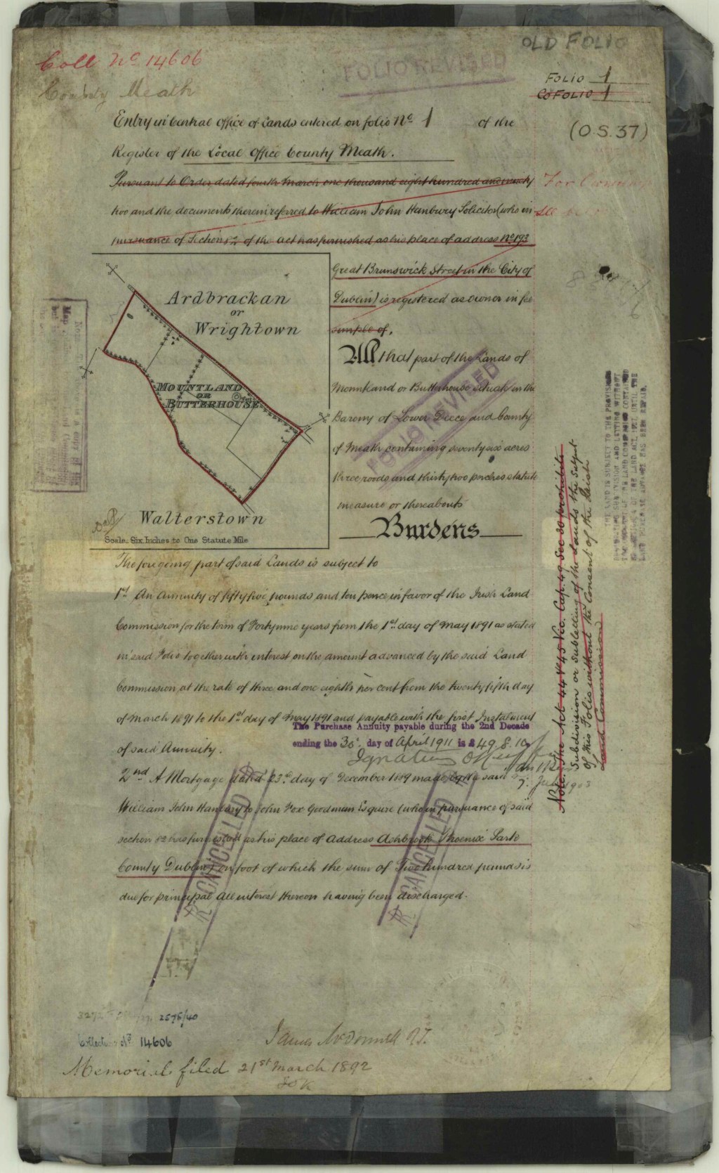
Under the Land Purchase Acts, agricultural land in Ireland was purchased from the Landlords and vested in the tenants on the land. The Land Commission’s work facilitated the need for an efficient way of recording and proving land ownership for the tenants. The Land Registry was established under the Registrations of Title (Ireland) Act 1891 to provide a state guaranteed title to the vested lands. The Central Office of the Land Registry opened in the Land Judges Office in the Four Courts, Dublin in 1892.
1922

On the 14 April 1922, the Land Registry offices in the Four Courts were occupied by anti-treaty soldiers. The Registrar, William Glover, made arrangements to relocate Land Registry staff to the Registry of Deeds building on Henrietta Street. On 28 June 1922, troops of the Free State Army began firing on the Four Courts complex. Two days of fighting followed, with an explosion destroying the Public Records Office and damaging part of the Land Registry building. Land Registry mapping sheets and instruments for over 7,500 folios were destroyed. It would be 67 weeks before the staff could return to the Four Courts.
1924
On the establishment of the new Irish Free State, responsibility for the Ordnance Survey Office was transferred to the Irish Government’s Department of Finance. All staff employed by the Ordnance Survey Office continued to be recruited through military channels until the 1970s, when the first civilian, and the first female, employees were recruited.
1965

Aerial photogrammetry was first introduced into the Ordnance Survey in Ireland in 1965, whereby film cameras in the aircraft was used to capture imagery to enable surveyors using photogrammetric instruments to identify and plot new features on the map.
1978
The Landlord and Tenant (Ground Rents) (No 2) Act 1978 which came into operation on 1st July 1978 provided a new method for the purchase of ground rents on dwellinghouses, and the Land Registry was entrusted with the administration of a new scheme. Since the scheme was introduced in 1978, over 80,000 applicants have availed of the service and have acquired a freehold title to their property.
Domestic rates are entirely abolished in Ireland by the Local Government (Financial Provisions) Act 1978. The Valuation revision books and maps only contain details of the ratable value of commercial properties from 1990s onwards.
2001
The Ordnance Survey Ireland was introduced as a State Body under the Ordnance Survey Ireland Act 2001.
The Valuation Act 2001 introduced a gradual roll of out of revaluations for all local authority areas.
2006

Under the Registration of Deeds and Title Act 2006, the Property Registration Authority (PRA) was established on 4 November 2006. The PRA replaced the Registrar of Deeds and Titles as the registering authority in Ireland responsible for managing and controlling the Land Registry.
2009

The Land Register and the associated maps were converted from paper to a fully digitised format, making the Registry map available to all members of the public to search on landdirect.ie for the first time.
2023

Tailte Éireann was formally established on 01 March 2023 starting the next chapter for land and property services in Ireland.