GeoHive - Explore for yourself

Discover how to start using GeoHive, the state’s Geospatial Data Hub to find the data you need to answer your questions.
Discover how to start using GeoHive, the state’s Geospatial Data Hub to find the data you need to answer your questions.

Do you want to know where land exists for new housing developments? Do you want to know where the best habitats are for hen harriers and other birds of prey? Do you want to know what proportion of young people are in full-time education in your town? Do you want to know the name of that wreck just off the mouth of Waterford Harbour? Whatever you want to know, GeoHive could have the answers.
GeoHive, the state’s Geospatial Data Hub, provides a wealth of information and current data about almost all aspects of life in Ireland, from society and health to agriculture, economic development, and the environment. Developed by Tailte Éireann - Surveying and adopted by the Irish government, GeoHive is free and easy for anyone to use. It provides people with three different ways to find and access data and removes the need for specialist software, training or skills.
View interactive maps
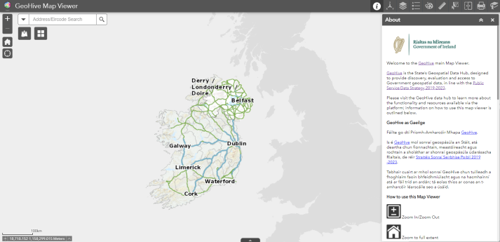
The first way to access data is via the GeoHive Map Viewer, a simple-to-use interactive map that allows users to find data relating to specific locations. You can, for example, select data on air quality, water contaminants and plastic debris in marine environments, to start to build up a picture of pollution in a specific location and make visual comparisons with other parts of the country. It is easy to find data to add to the map using the search box or data catalogue tab and you can filter the data presented by relevance, title, owner, rating, views or date until you find exactly what you need.
New functionalities added to the platform will enable people to save and share the map views that they create directly from the GeoHive Map Viewer. You will then be able to embed your saved maps into websites, web mapping applications, information dashboards and story maps. Users can already customise their maps, by selecting from a choice of base maps, draw on their maps and measure distances within the GeoHive Map Viewer. People can also swipe between different views to get a deeper understanding of individual sites or entire regions.
Browse the data catalogue
As an alternative to using the interactive map, you can access data via the GeoHive Map Viewer. In this section of GeoHive, all available geospatial data is aligned with gov.ie categories, such as environment, energy, health, and housing and zoning. Users can click on topics in the sidebar to filter their results and find links to authoritative, up-to-date data resources. Search results can be viewed on an interactive map or downloaded for analysis in geographic information system (GIS) applications.
In the health section, you can find and view or download data ranging from smoking prevalence and obesity rates to fatal traffic accidents and the proportion of people with disabilities in employment. Alternatively, a quick perusal of the population and society category will lead to information on the proportion of women in managerial roles, access to public transport and growth in household expenditure. The environment section alone contains over 265 different data sets, providing access to respected information about everything from the current levels of greenhouse gas emissions and the geology of Ireland, right down to the best habitats for otters – and much, much more.
Explore existing resources by theme
Finally, users can take advantage of the themes section of GeoHive to access a cornucopia of online web apps, story maps and dashboards created and maintained by different public service bodies, as well as research groups. This section includes several highly successful initiatives that Tailte Éireann - Surveying has collaborated on with other public service bodies such as the Environmental Sensitivity Map, a web-based decision-support tool for environmental assessment and planning in Ireland, developed by University College Dublin, in collaboration with the Environmental Protection Agency and AIRO.
People who are interested in development planning can go to GeoHive Themes to gain easy access to Myplan.ie, a web map portal providing spatial information relevant to the planning process in Ireland that is maintained by the Department of Housing, Local Government and Heritage in conjunction with Irish local authorities. At the other end of the scale, people who live near Wexford can use GeoHive Themes to find out more about where to spot butterflies in an interactive story map, provided by the Department of the Arts, Heritage and the Gaeltacht to encourage visitors to the Raven Nature Reserve.
Historic Maps & Townland viewer
For users particularly interested in Tailte Éireann - Surveying Historic Mapping, we have developed the Historic Maps & Townland viewer which enables users to search for Townlands, view historical features, and choose from a set of historical and current basemaps. It also allows users to overlay our historic mapping services over our most up-to-date maps available, and use transparency and swipe functionality to understand change over time.
We have also developed two new interactive dashboards which allow users to explore how the Irish landscape has changed over time.
The National Historic Maps dashboard shows our historic mapping services in a single view, and allows users to pan and zoom to their area of interest.
The National Aerial Imagery Dashboard shows our national imagery in a single view, and allows users to pan and zoom to their area of interest.

Build a better future for Ireland
GeoHive is already live and available for use. Tailte Éireann – Surveying anticipates that the platform will primarily be used by public service bodies such as local authorities and central government departments to help them make well-informed decisions about the development of new services for citizens. The Dublin Housing Observatory, which is hosted on GeoHive, is already being used to provide insight into the Dublin housing market and shape the future of housing development in the city.
While public sector bodies are likely to be the heaviest users of GeoHive, the platform can be used by anyone. Environmental organisations, commercial businesses, community groups and citizens can explore GeoHive to find and analyse data and find the answers to their questions. The data and resources that can be accessed from GeoHive will help everyone to find out more about the places, the people and the issues that they care most about. We can then all make the right decisions to build a better future for Ireland.
Back to All